
Fil:Battlefields (approx.) - U.S. Army and Lakotas, 1854-1868 (blue x) and 1869-1890 (red x).png
Battlefields_(approx.)_-_U.S._Army_and_Lakotas,_1854-1868_(blue_x)_and_1869-1890_(red_x).png (500 × 371 billedpunkter, filstørrelse: 302 KB, MIME-type: image/png)
|
|
Denne fil er fra Wikimedia Commons. Beskrivelsen af filen fra Commons er gengivet nedenfor. |
_-_U.S._Army_and_Lakotas,_1854-1868_(blue_x)_and_1869-1890_(red_x).png?uselang=da)
Beskrivelse
| Beskrivelse |
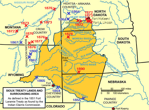
Dansk: Kortet viser lakotaernes land ifølge Fort Laramie traktaten (1851) og mange af kamppladserne mellem dem og den amerikanske hær i tiden 1854-1868 (blåt X) og igen fra 1869-1890 (rødt X). De fleste kampe blev udkæmpet udenfor lakotaernes traktat-områder, hvor de kun opholdt sig efter at have bekriget nogle af de små nabostammer tidligere og erobret land fra dem. Først og fremmest crowerne led under lakotaernes vedvarende invasion af områderne vest for Powder River: Berømte kampe som Wagon Box Fight, Fetterman-massakren, Hayfield Fight, Rosebud slaget og Custer slaget ved Little Bighorn River i Montana blev alle udkæmpet på dele af prærien, som lakotaerne havde anerkendt var fjenderne i crow-stammens territorium i 1851.
English: The map shows the land of the Lakotas according to the Fort Laramie Treaty (1851) and many of the battlefields between them and the U.S. Army from 1854 to 1868 (blue X) and again from 1869-1890 (red X). Most battles were fought outside the Lakota territory because the Lakotas had taken treaty defined native territories from the smaller, hostile tribes West and North of them in the years after 1851. Foremost the traditional enemies of the Lakotas in the Crow Nation suffered under the persistent Lakota intrusion into the areas West of Powder River: Battles like Wagon Box Fight, the Fetterman Massacre, Hayfield Fight, Battle of the Rosebud and the Battle of the Little Bighorn River (”the Custer Battle”) in Montana were fought in parts of the plains acknowledged as Crow soil by the Lakotas in 1851.
Some of the sources used: Record of Engagements with Hostile Indians within the Military Division of Missouri, from 1868 to 1882, Lieutenant General P. H. Sheridan, Commanding. Compiled from Official Records. Headquarters Military Division of the Missouri, Chicago, Illinois. 1882. Robertson, Francis B.: ““We Are Going to Have a Big Sioux War”. Colonel David S. Stanley’s Yellowstone Expedition, 1872.” Montana, The Magazine of Western History. Vol. 34, No. 4, Autumn 1984. Pp. 2-15. Brown, Dee: Bury My Heart at Wounded Knee. Hyde, George E.: Life of George Bent. Written From His Letters. Norman, 1987. McCann, Lloyd E.: ”The Grattan Massacre.” Nebraska History. Vol. 37, No. 1 (March, 1956). Pp. 1-26. Bettelyoun, Susan Bordeaux and Josephine Waggoner: ”Three Stories of the Battle of the Blue Water.” With My Own Eyes. A Lakota Woman Tells Her People’s History. Lincoln and London. 1998. NATIONAL HISTORIC LANDMARK NOMINATION. WOLF MOUNTAINS BATTLEFIELD/WHERE BIG CROW WALKED BACK AND FORTH. United States Department of the Interior, National Park Service. Medicine Crow, Joseph: From The Heart Of The Crow Country. The Crow Indians’ Own Stories. New York, 1992 The Apsaalooke (Crow Indians) of Montana. A Tribal Histories Teachers's Guide. Compiled and Edited by Phenocia Bauerle, Cindy Bell, Luella Brien, Carrie McCleary, Timothy McCleary and Hubert B. Two Leggings. Little Bighorn College. Crow Agency, Montana. OPI.MT.GOV 2010. White, Richard: ”The Winning of the West: The Expansion of the Western Sioux in the Eighteenth and Nineteenth Centuries.” The Journal of American History. Vol. 65, No. 2 (Sep., 1978). Pp. 319-343. Remele, Larry (Ed.): Fort Buford and the Military Frontier on the Northern Plains. Bismarck, ND. 1987. Hoxie, Frederick E.: Parading Through History. The making of the Crow Nation in America, 1805-1935. Cambridge, 1995. |
| Dato | |
| Kilde | Wikimedia Commons file: Sioux-treaty-lands.png (The original map is adapted to show a number of the battlefields between the U.S. Army and the Lakotas, 1854-1890) |
| Forfatter | Uploaded by Somaeye |
Licensering
Dette værk er offentlig ejendom i Amerikas Forenede Stater (USA) fordi det blev udgivet (eller registreret hos U.S. Copyright Office) før 1 januar 1929.
For at et værk skal kunne lægges på Commons som offentlig ejendom skal ophavsretten være udløbet i både USA og oprindelseslandet. Hvis værket ikke er amerikansk, skal det have yderligere en ophavsretslicens, der angiver ophavsretsstatus i oprindelseslandet.
|

|
This is a file uploaded through the Danish Wikipedia, which has not been reviewed on Commons:
|
Filhistorik
Klik på en dato/tid for at se filen som den så ud på det tidspunkt.
| Dato/tid | Miniaturebillede | Dimensioner | Bruger | Kommentar | |
|---|---|---|---|---|---|
| nuværende | 18. sep. 2022, 10:51 | | 500 × 371 (302 KB) | Indianertosset | Uploaded a work by Uploaded by Somaeye from Wikimedia Commons file: Sioux-treaty-lands.png (The original map is adapted to show a number of the battlefields between the U.S. Army and the Lakotas, 1854-1890) with UploadWizard |
Filanvendelse
De følgende 2 sider bruger denne fil:
_-_U.S._Army_and_Lakotas,_1854-1868_(blue_x)_and_1869-1890_(red_x).png)